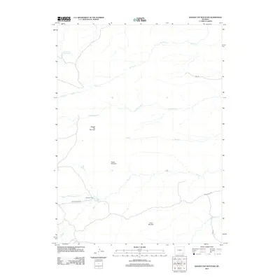
2012 Map of Ragged Top Mountain
USGS Topo · Published 2012About this map
Ragged Top Mountain rises as a prominent landmark in this high-plains landscape, where the drainage systems of the Laramie Range define the local topography. This 2012 survey by the U.S. Geological Survey illustrates a sparsely populated ranching environment centered on the Mckechnie Ranch along Horse Cr. The area is characterized by significant vertical relief, with Powell Mountain and Horse Mountain providing elevation between the branching waterways of Ricker Cr and the N Fork Horse Cr. Human activity is concentrated along established corridors like Roger Canyon Rd and Fisher Canyon Rd, while the Alvie Number One Reservoir in the northwest corner highlights the importance of water management in this arid cattle-country terrain.
Find a feature on this map
16 named features on this map. Tap any name to fly to it.
Don’t see what you’re looking for? This feature index may not catch every label — zoom into the map to look around manually.
Map Details
Editions of this 2012 Ragged Top Mountain Map
This is the sole edition of this map. No revisions or reprints were ever made.
Other maps of this area

1905 · Sherman
USGS Topo · 1:125,000

1948 · Ragged Top Mountain
USGS Topo · 1:62,500

1950 · Ragged Top Mountain
USGS Topo · 1:62,500

1954 · Cheyenne
USGS Topo · 1:250,000

1955 · Baldy Mountain
USGS Topo · 1:24,000

1955 · Goat Mountain
USGS Topo · 1:24,000

1958 · Cheyenne
USGS Topo · 1:250,000

1962 · Horse Creek
USGS Topo · 1:24,000

1962 · Farthing
USGS Topo · 1:24,000
1962 · Islay
USGS Topo · 1:24,000