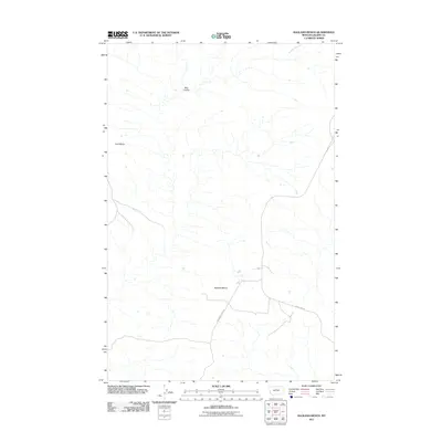
2011 Map of Ragland Bench
USGS Topo · Published 2011About this map
Ragland Bench and Golf Bench dominate this high Montana landscape in Blaine County, where the topography is defined by broad, flat-topped landforms dissected by ephemeral drainages. The area is characterized by its isolation and its connection to the regional transport network via Ragland Ridge Rd and Cleveland Rd, which provide access through the open country. Water is a defining yet scarce element here, represented primarily by Bills Coulee, a seasonal channel that carves through the terrain. This 2011 survey by the U.S. Geological Survey captures the quiet, rural character of the Big Sky region, documenting the precise elevations and road alignments that serve the local ranching and agricultural community in this corner of the state.
Find a feature on this map
5 named features on this map. Tap any name to fly to it.
Don’t see what you’re looking for? This feature index may not catch every label — zoom into the map to look around manually.
Map Details
Editions of this 2011 Ragland Bench Map
This is the sole edition of this map. No revisions or reprints were ever made.
Other maps of this area

1954 · Taffy Ridge
USGS Topo · 1:24,000

1954 · Leroy
USGS Topo · 1:24,000

1954 · Gallatin Rapids
USGS Topo · 1:24,000

1954 · Council Island
USGS Topo · 1:24,000

1954 · Lewistown
USGS Topo · 1:250,000

1959 · Lewistown
USGS Topo · 1:250,000

1964 · Ragland Bench
USGS Topo · 1:24,000

1964 · Chase Hill
USGS Topo · 1:24,000
1984 · Eskay NE
USGS Topo · 1:24,000
1985 · Nolan Reservoir
USGS Topo · 1:24,000