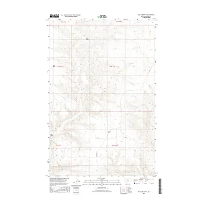
2017 Map of Ragland Bench
USGS Topo · Published 2017About this map
Ragland Bench and Golf Bench dominate this northern Montana landscape, where flat-topped elevations provide a stark contrast to the drainage networks of Bills Coulee and Black Coulee. This 2017 survey reflects the remote character of southern Blaine County, centered on the high plains between the Little Rocky Mountains and the Milk River valley. The infrastructure is minimal, defined by long stretches of gravel travel along Lloyd Rd and Raglan Ridge Rd, which follow the natural contours of the land and section lines of the Public Land Survey System. The map documents the vast townships of T24N and T23N, where the land is primarily organized for ranching and large-scale agricultural use within the high Missouri River breaks region.
Find a feature on this map
12 named features on this map. Tap any name to fly to it.
Don’t see what you’re looking for? This feature index may not catch every label — zoom into the map to look around manually.
Map Details
Editions of this 2017 Ragland Bench Map
This is the sole edition of this map. No revisions or reprints were ever made.
Other maps of this area

1954 · Taffy Ridge
USGS Topo · 1:24,000

1954 · Leroy
USGS Topo · 1:24,000

1954 · Gallatin Rapids
USGS Topo · 1:24,000

1954 · Council Island
USGS Topo · 1:24,000

1954 · Lewistown
USGS Topo · 1:250,000

1959 · Lewistown
USGS Topo · 1:250,000

1964 · Ragland Bench
USGS Topo · 1:24,000

1964 · Chase Hill
USGS Topo · 1:24,000
1984 · Eskay NE
USGS Topo · 1:24,000
1985 · Nolan Reservoir
USGS Topo · 1:24,000