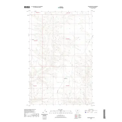
2020 Map of Ragland Bench
USGS Topo · Published 2020About this map
Ragland Bench and Golf Bench define this portion of Blaine County, where the high plains of north-central Montana break into a complex system of coulees and ridges. This 2020 survey shows a landscape primarily shaped by topography and ranching access, centered on the divide between these two prominent plateau features. The presence of Lloyd Rd and Raglan Ridge Rd suggests a sparse transportation network following the natural contours of the land. This map provides a clear view of the Public Land Survey System divisions, including sections within t24n r18e and t23n r17e, which are essential for identifying historical land patents and grazing allotments. The detailed contour intervals reveal the intricate drainage patterns that fall away from the benches, offering a precise record of the regional geography as it stood in the early 21st century.
Find a feature on this map
10 named features on this map. Tap any name to fly to it.
Don’t see what you’re looking for? This feature index may not catch every label — zoom into the map to look around manually.
Map Details
Editions of this 2020 Ragland Bench Map
This is the sole edition of this map. No revisions or reprints were ever made.
Other maps of this area

1954 · Taffy Ridge
USGS Topo · 1:24,000

1954 · Leroy
USGS Topo · 1:24,000

1954 · Gallatin Rapids
USGS Topo · 1:24,000

1954 · Council Island
USGS Topo · 1:24,000

1954 · Lewistown
USGS Topo · 1:250,000

1959 · Lewistown
USGS Topo · 1:250,000

1964 · Ragland Bench
USGS Topo · 1:24,000

1964 · Chase Hill
USGS Topo · 1:24,000
1984 · Eskay NE
USGS Topo · 1:24,000
1985 · Nolan Reservoir
USGS Topo · 1:24,000