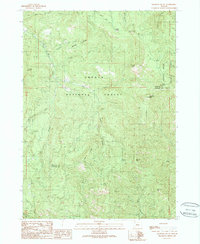
1989 Map of Ragsdale Butte
USGS Topo · Published 1990About this map
Umpqua National Forest and Rogue River National Forest meet in this high-elevation wilderness along the border of Douglas and Jackson counties. The landscape is defined by its prominent geologic formations and water sources, including the namesake Ragsdale Butte and the nearby Ragsdale Spring. A sparse network of trails and unimproved roads connects the few human landmarks, most notably the Summit Cabin in the northeast and the Threehorn Campground near Mitchell Creek. This survey captures the area in the late 1980s, revealing a terrain utilized primarily for recreation and forest management. Named peaks like Devils Knob, Hawk Mountain, and Cowbell Mountain rise above the drainage systems of Elk Creek and Flat Creek, while the Savage Bluffs overlook the remote eastern reaches of the quadrangle.
Find a feature on this map
38 named features on this map. Tap any name to fly to it.
Don’t see what you’re looking for? This feature index may not catch every label — zoom into the map to look around manually.
Map Details
Editions of this 1989 Ragsdale Butte Map
This is the sole edition of this map. No revisions or reprints were ever made.
Other maps of this area

1891 · Ashland
USGS Topo · 1:250,000

1893 · Ashland
USGS Topo · 1:250,000

1897 · Ashland
USGS Topo · 1:250,000

1943 · Trail
USGS Topo · 1:62,500

1944 · Tiller
USGS Topo · 1:62,500

1944 · Abbott Butte
USGS Topo · 1:62,500

1947 · Abbott Butte
USGS Topo · 1:62,500

1954 · Butte Falls
USGS Topo · 1:62,500

1955 · Medford
USGS Topo · 1:250,000

1957 · Medford
USGS Topo · 1:250,000