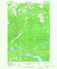
1964 Map of Rainbow Falls
USGS Topo · Published 1966About this map
The Raquette River dominates the southern landscape of this 1960s survey, illustrating a mid-century industrial environment shaped by hydroelectric development. Engineered features such as the Five Falls Reservoir, Rainbow Falls Reservoir, and associated powerplants and aqueducts define the waterway’s path through Colton and Parishville. These modern interventions contrast with the older rural character of the region, evidenced by the small settlement of Pickettville and the industrial remnants along Rodwell Mill Rd.
Find a feature on this map
57 named features on this map. Tap any name to fly to it.
Don’t see what you’re looking for? This feature index may not catch every label — zoom into the map to look around manually.
Map Details
Editions of this 1964 Rainbow Falls Map
Other maps of this area

1908 · Potsdam
USGS Topo · 1:62,500

1919 · Nicholville
USGS Topo · 1:62,500

1920 · Childwold
USGS Topo · 1:62,500

1921 · Childwold
USGS Topo · 1:48,000

1921 · Nicholville
USGS Topo · 1:62,500

1921 · Stark
USGS Topo · 1:62,500

1922 · Childwold
USGS Topo · 1:62,500

1923 · Stark
USGS Topo · 1:62,500

1940 · Stark
USGS Topo · 1:62,500

1942 · Long Bow
USGS Topo · 1:24,000