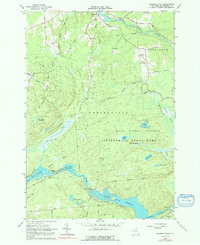
1964 Map of Rainbow Falls
USGS Topo · Published 1991About this map
Raquette River hydro-power infrastructure dominates this mid-century landscape in St. Lawrence County, defined by a sequence of man-made impoundments. The Five Falls Reservoir and Rainbow Falls Reservoir illustrate the mid-20th-century development of the river, complete with a Powerplant and Aqueduct system near Rainbow Falls. To the north, the small settlement of Pickettville sits near the intersection of Barton Road and Pickettville Road, serving as a gateway to the expansive State Forest Preserve and Adirondack State Park.
Find a feature on this map
59 named features on this map. Tap any name to fly to it.
Don’t see what you’re looking for? This feature index may not catch every label — zoom into the map to look around manually.
Map Details
Editions of this 1964 Rainbow Falls Map
Other maps of this area

1908 · Potsdam
USGS Topo · 1:62,500

1919 · Nicholville
USGS Topo · 1:62,500

1920 · Childwold
USGS Topo · 1:62,500

1921 · Childwold
USGS Topo · 1:48,000

1921 · Nicholville
USGS Topo · 1:62,500

1921 · Stark
USGS Topo · 1:62,500

1922 · Childwold
USGS Topo · 1:62,500

1923 · Stark
USGS Topo · 1:62,500

1940 · Stark
USGS Topo · 1:62,500

1942 · Long Bow
USGS Topo · 1:24,000