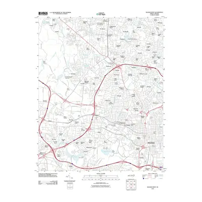
2010 Map of Raleigh West
USGS Topo · Published 2010About this map
The western expansion of Raleigh is documented here as the capital's suburban and institutional corridors matured into a dense network of neighborhoods. Educational and civic landmarks anchor the eastern half, including the sprawling campus of North Carolina State University, the historic grounds of Shaw University, and prominent venues like Dorton Arena and Reynolds Coliseum. The map highlights the city's complex relationship with its waterways, showing significant drainage systems such as Walnut Creek and Crabtree Creek alongside man-made features like the Lake Johnson Dam and Lake Raleigh Dam.
Find a feature on this map
164 named features on this map. Tap any name to fly to it.
Don’t see what you’re looking for? This feature index may not catch every label — zoom into the map to look around manually.
Map Details
Editions of this 2010 Raleigh West Map
This is the sole edition of this map. No revisions or reprints were ever made.
Other maps of this area

1943 · Durham South
USGS Topo · 1:62,500

1943 · Raleigh
USGS Topo · 1:62,500

1951 · Raleigh
USGS Topo · 1:62,500

1951 · Durham South
USGS Topo · 1:62,500

1953 · Raleigh
USGS Topo · 1:250,000

1954 · Raleigh
USGS Topo · 1:250,000

1964 · Lake Wheeler
USGS Topo · 1:24,000

1964 · Garner
USGS Topo · 1:24,000

1964 · Garner
USGS Topo · 1:62,500
1967 · Wake Forest
USGS Topo · 1:24,000