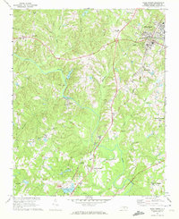
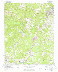
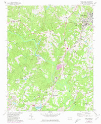
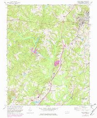
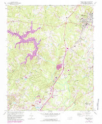
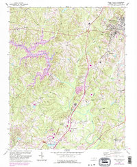
1967 Map of Wake Forest
USGS Topo · Published 1972About this map
Wake Forest serves as the focal point of this late 1960s survey, defined by the prominent campus of the Southeastern Theological Seminary and its proximity to the Seaboard Coast Line railroad. The landscape is deeply tied to the Neuse River, which winds through the center of the sheet, supporting a series of small riverside and crossroads communities. To the south and west, the map details the infrastructure of the era, including a Filtration Plant, Reservoir, and several Quarry sites that hint at the local extraction industry. Rural life is anchored by numerous country churches such as Stony Hill Ch and Mt Vernon Ch, while recreational spaces like New Life Camp and Camp Durant indicate the transition of the land toward youth and community use. The presence of Forestville and Falls illustrates the historical settlement patterns that grew along the rail lines and river bends.
Find a feature on this map
42 named features on this map. Tap any name to fly to it.
Don’t see what you’re looking for? This feature index may not catch every label — zoom into the map to look around manually.
Map Details
Editions of this 1967 Wake Forest Map
6 editions found
Other maps of this area

1943 · Raleigh
USGS Topo · 1:62,500

1943 · Creedmoor
USGS Topo · 1:62,500

1944 · Creedmoor
USGS Topo · 1:62,500

1951 · Raleigh
USGS Topo · 1:62,500

1953 · Raleigh
USGS Topo · 1:250,000

1953 · Greensboro
USGS Topo · 1:250,000

1954 · Greensboro
USGS Topo · 1:250,000

1954 · Raleigh
USGS Topo · 1:250,000

1962 · Greensboro
USGS Topo · 1:250,000

1966 · Greensboro
USGS Topo · 1:250,000