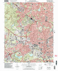
2002 Map of Raleigh West
USGS Topo · Published 2004About this map
The western expansion of Raleigh is clearly visible in this detailed study, where institutional growth and urban infrastructure meet preserved green spaces. The sprawling campus of North Carolina State University and neighboring Meredith College dominate the central landscape, accompanied by the NCSU Research Unit. These educational hubs are flanked by significant landmarks such as the Dorton Arena, Carter Stadium, and the expansive Dorothea Dix State Hospital grounds. This geography reflects a period of intensive development, where major thoroughfares like Wade Ave and Western Blvd intersect with established rail corridors of the Norfolk Southern and Seaboard Coast Line.
Find a feature on this map
68 named features on this map. Tap any name to fly to it.
Don’t see what you’re looking for? This feature index may not catch every label — zoom into the map to look around manually.
Map Details
Editions of this 2002 Raleigh West Map
This is the sole edition of this map. No revisions or reprints were ever made.
Other maps of this area

1943 · Durham South
USGS Topo · 1:62,500

1943 · Raleigh
USGS Topo · 1:62,500

1951 · Raleigh
USGS Topo · 1:62,500

1951 · Durham South
USGS Topo · 1:62,500

1953 · Raleigh
USGS Topo · 1:250,000

1954 · Raleigh
USGS Topo · 1:250,000

1964 · Lake Wheeler
USGS Topo · 1:24,000

1964 · Garner
USGS Topo · 1:24,000

1964 · Garner
USGS Topo · 1:62,500
1967 · Wake Forest
USGS Topo · 1:24,000