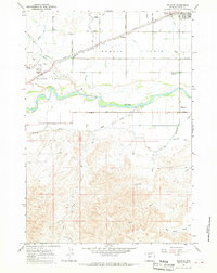
1967 Map of Ralston
USGS Topo · Published 1971About this map
The irrigated agricultural landscape of Powell Flats and Ralston Flats dominates this mid-century survey of the Big Horn Basin. Bordered by the Shoshone River to the south, the region is defined by a rigid grid of numbered roads and lanes, such as Fourteen Road and Lane Ten, which facilitate the movement of water and crops. The Chicago Burlington and Quincy railroad line cuts diagonally across this grid, serving the settlements of Ralston and O'Donnell.
Find a feature on this map
32 named features on this map. Tap any name to fly to it.
Don’t see what you’re looking for? This feature index may not catch every label — zoom into the map to look around manually.
Map Details
Editions of this 1967 Ralston Map
2 editions found
Other maps of this area

1955 · Cody
USGS Topo · 1:250,000

1958 · Cody
USGS Topo · 1:250,000

1962 · Cody
USGS Topo · 1:250,000

1966 · Elk Basin SW
USGS Topo · 1:24,000

1966 · Stone Barn Camp
USGS Topo · 1:24,000

1966 · Garland
USGS Topo · 1:24,000

1966 · Elk Basin SE
USGS Topo · 1:24,000

1966 · Gilmore Hill NW
USGS Topo · 1:24,000

1966 · Corbett Dam
USGS Topo · 1:24,000

1966 · Gilmore Hill
USGS Topo · 1:24,000