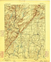
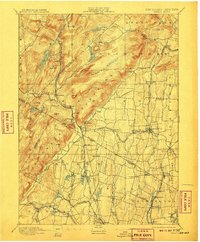
1893 Map of Ramapo
USGS Topo · Published 1898About this map
The Ramapo Mountains dominate this late nineteenth-century landscape, acting as a natural divide between the rugged uplands and the developing valley settlements to the southeast. The New York Lake Erie and Western Railroad snakes through the narrow gap carved by the Ramapo River, anchoring a string of vital junctions and whistle-stops including Sloatsburg, Ramapo, and Suffern. In the lowlands, a dense network of smaller communities like Spring Valley and Monsey are interconnected by the Piermont Branch, illustrating a period when rail transit dictated the growth of local economies.
Find a feature on this map
86 named features on this map. Tap any name to fly to it.
Don’t see what you’re looking for? This feature index may not catch every label — zoom into the map to look around manually.
Map Details
Editions of this 1893 Ramapo Map
6 editions found

Other maps of this area

1888 · Morristown
USGS Topo · 1:62,500

1888 · Paterson
USGS Topo · 1:62,500

1891 · Greenwood Lake
USGS Topo · 1:62,500

1891 · Ramapo
USGS Topo · 1:62,500

1891 · Harlem
USGS Topo · 1:62,500

1892 · West Point
USGS Topo · 1:62,500

1892 · Paterson
USGS Topo · 1:62,500

1892 · Tarrytown
USGS Topo · 1:62,500

1893 · Greenwood Lake
USGS Topo · 1:62,500

1893 · Tarrytown
USGS Topo · 1:62,500