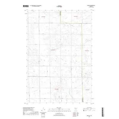
2019 Map of Ramey NE
USGS Topo · Published 2019About this map
The W Br Rum River and its various tributaries define the wetland-rich landscape of this part of Page Township in the late 2010s. The map illustrates a highly organized grid of rural roads, including Sage Rd, 390th Ave, and Co Rd 39, which segment the land into traditional township sections. Waterways like Tibbetts Brook, S Fork Bradbury Brook, and Burnt Lane Brook meander through low-lying areas, highlighting the complex drainage patterns of the region. The boundary between Morrison and Mille Lacs counties runs vertically through the eastern portion of the sheet, dividing the survey area between Townships 39, 40, and 41 North. This topographical survey captures the modern rural infrastructure of the area, where sparse residential development follows the established lines of numbered streets like 103rd St and 153rd St.
Find a feature on this map
32 named features on this map. Tap any name to fly to it.
Don’t see what you’re looking for? This feature index may not catch every label — zoom into the map to look around manually.
Map Details
Editions of this 2019 Ramey NE Map
This is the sole edition of this map. No revisions or reprints were ever made.
Other maps of this area

1953 · Duluth
USGS Topo · 1:250,000

1953 · Stillwater
USGS Topo · 1:250,000

1955 · Stillwater
USGS Topo · 1:250,000

1958 · Stillwater
USGS Topo · 1:250,000

1958 · Duluth
USGS Topo · 1:250,000

1965 · Stillwater
USGS Topo · 1:250,000

1968 · Ramey NE
USGS Topo · 1:24,000

1968 · Onamia
USGS Topo · 1:24,000
1968 · Ramey NW
USGS Topo · 1:24,000

1968 · Rum River
USGS Topo · 1:24,000