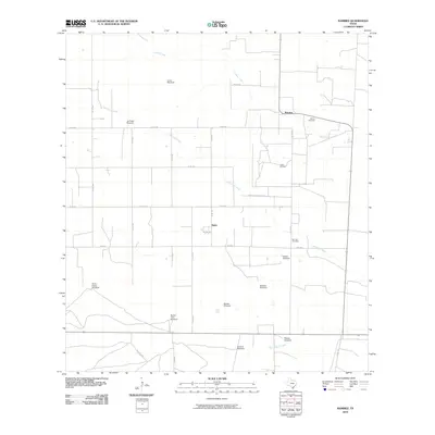
2010 Map of Ramirez
USGS Topo · Published 2010About this map
Ramirez and the surrounding ranchlands of Duval County are defined by a network of drainage ways and named landmarks vital to the regional livestock economy. The landscape is crossed by Cibolo Creek, Laborcitas Creek, and Palo Blanco Creek, providing the primary natural drainage for this South Texas territory. Human activity is evidenced by numerous namesake landmarks, particularly a significant concentration of windmills such as Llano Windmill, Buena Vista Windmill, and Oscars Windmill, which reflect the importance of groundwater in this semi-arid environment.
Find a feature on this map
30 named features on this map. Tap any name to fly to it.
Don’t see what you’re looking for? This feature index may not catch every label — zoom into the map to look around manually.
Map Details
Editions of this 2010 Ramirez Map
This is the sole edition of this map. No revisions or reprints were ever made.
Other maps of this area

1921 · Falfurrias
USGS Topo · 1:125,000

1956 · Laredo
USGS Topo · 1:250,000

1967 · Hebbronville SE
USGS Topo · 1:24,000

1967 · Realitos
USGS Topo · 1:24,000

1968 · Palomas Ranch NW
USGS Topo · 1:24,000

1968 · Concepcion
USGS Topo · 1:24,000

1968 · Concepcion NW
USGS Topo · 1:24,000

1968 · Palomas Ranch
USGS Topo · 1:24,000
1969 · Laguna Del Toro
USGS Topo · 1:24,000
1969 · Ramirez
USGS Topo · 1:24,000