
1967 Map of Realitos
USGS Topo · Published 1971About this map
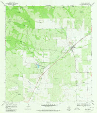
Realitos serves as the central hub of this South Texas landscape, defined by the diagonal passage of the Texas Mexican railroad. This 1967 survey reveals a ranching economy reliant on scattered water sources, documented through numerous family-named landmarks such as the Rancho Nuevo Windmill, Palo Blanco Windmill, and Haner Windmill. The topography is shaped by the drainages of Macho Creek, Laborcitas Creek, and Cibolo Creek, which cut through the terrain punctuated by earthen tanks like Guaturche Tank and Cuerva Tank. Resource extraction is evident through several Gravel Pits and an Oil Well near the Realitos S Base geodetic marker. The map provides a clear record of the rural infrastructure of Duval County during the late 1960s, showing the intersection of rail transport, livestock management, and early petroleum development.
Find a feature on this map
24 named features on this map. Tap any name to fly to it.
Don’t see what you’re looking for? This feature index may not catch every label — zoom into the map to look around manually.
Map Details
Editions of this 1967 Realitos Map
2 editions found
Other maps of this area

1921 · Falfurrias
USGS Topo · 1:125,000

1956 · Benavides
USGS Topo · 1:62,500

1956 · Laredo
USGS Topo · 1:250,000

1967 · Hebbronville SE
USGS Topo · 1:24,000

1967 · Parrilla Creek SE
USGS Topo · 1:24,000

1967 · Hebbronville NW
USGS Topo · 1:24,000

1967 · Hebbronville
USGS Topo · 1:24,000

1968 · Parrilla Creek SW
USGS Topo · 1:24,000

1968 · Benavides
USGS Topo · 1:24,000

1968 · Concepcion NW
USGS Topo · 1:24,000