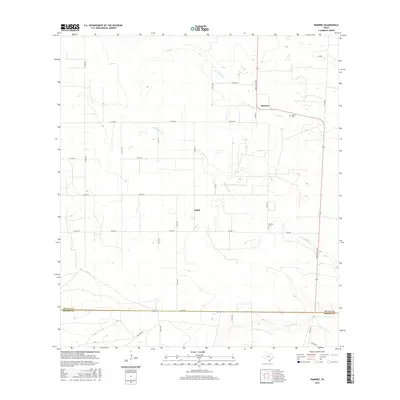
2016 Map of Ramirez
USGS Topo · Published 2016About this map
Ramirez and Sejita anchor this landscape of the South Texas brush country, where the intersection of Ranch Rd 1345 and FM 3249 marks a central point of settlement. The map reveals a rural community structure defined by small family cemeteries such as Ramirez Cem and Ramos Cem, which provide valuable location data for genealogists tracing South Texas families. The drainage of the land is defined by seasonal waterways including Cibolo Cr, Laborcitas Cr, and Palo Blanco Cr, which cut through the terrain and influence the placement of the local road network. Along the southern edge, the map identifies the administrative boundary between Duval Co and Brooks Co, where FM 285 runs parallel to the county line. The web of county roads, such as Co Rd 250 and Co Rd 256, suggests a landscape long utilized for ranching and agriculture.
Find a feature on this map
32 named features on this map. Tap any name to fly to it.
Don’t see what you’re looking for? This feature index may not catch every label — zoom into the map to look around manually.
Map Details
Editions of this 2016 Ramirez Map
This is the sole edition of this map. No revisions or reprints were ever made.
Other maps of this area

1921 · Falfurrias
USGS Topo · 1:125,000

1956 · Laredo
USGS Topo · 1:250,000

1967 · Hebbronville SE
USGS Topo · 1:24,000

1967 · Realitos
USGS Topo · 1:24,000

1968 · Palomas Ranch NW
USGS Topo · 1:24,000

1968 · Concepcion
USGS Topo · 1:24,000

1968 · Concepcion NW
USGS Topo · 1:24,000

1968 · Palomas Ranch
USGS Topo · 1:24,000
1969 · Laguna Del Toro
USGS Topo · 1:24,000
1969 · Ramirez
USGS Topo · 1:24,000