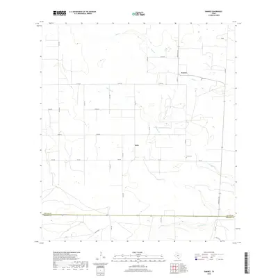
2019 Map of Ramirez
USGS Topo · Published 2019About this map
Ramirez and the nearby settlement of Sejita anchor this landscape along the Duval and Brooks County line. The terrain is defined by a network of intermittent watercourses, including Cibolo Creek and Laborcitas Creek, which trace winding paths through the brush country. This area is a patchwork of rural ranch roads, such as Co RD 250 and Ranch Road 1345, reflecting the region's agricultural and ranching heritage. Genealogical interest is centered on the local burial grounds, specifically Ramirez Cemetery and Ramos Cemetery, which provide a historical connection to the early families of this South Texas pocket. The southern edge of the map is marked by Palo Blanco Creek and Fm 285, illustrating the sparse but deliberate infrastructure connecting these rural communities.
Find a feature on this map
33 named features on this map. Tap any name to fly to it.
Don’t see what you’re looking for? This feature index may not catch every label — zoom into the map to look around manually.
Map Details
Editions of this 2019 Ramirez Map
This is the sole edition of this map. No revisions or reprints were ever made.
Other maps of this area

1921 · Falfurrias
USGS Topo · 1:125,000

1956 · Laredo
USGS Topo · 1:250,000

1967 · Hebbronville SE
USGS Topo · 1:24,000

1967 · Realitos
USGS Topo · 1:24,000

1968 · Palomas Ranch NW
USGS Topo · 1:24,000

1968 · Concepcion
USGS Topo · 1:24,000

1968 · Concepcion NW
USGS Topo · 1:24,000

1968 · Palomas Ranch
USGS Topo · 1:24,000
1969 · Laguna Del Toro
USGS Topo · 1:24,000
1969 · Ramirez
USGS Topo · 1:24,000