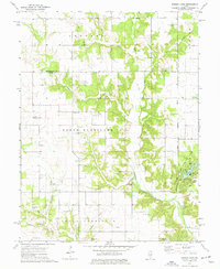
1974 Map of Ramsey
USGS Topo · Published 1977About this map
Ramsey Creek and its many tributaries, including Hurricane Creek and Otter Creek, carve through the rural landscapes of North Hurricane and South Hurricane townships in the 1970s. This agricultural region is punctuated by a high density of country burial grounds and small churches that anchor the local community. Genealogists will find many family-named sites, such as Tennessee Cem, Donaldson Cem, and Craig Cem, often situated near early church foundations like New Bethel Ch or Halford Chapel. The eastern edge of the map is dominated by the recreational waters of Ramsey Lake within Ramsey Lake State Park, showing the Campground and Picnic Area as they appeared during this era of state park development. The presence of the Third Principal Meridian running north-south through the townships of Audubon and Oconee highlights the fundamental surveying lines that defined these Illinois farmsteads.
Find a feature on this map
43 named features on this map. Tap any name to fly to it.
Don’t see what you’re looking for? This feature index may not catch every label — zoom into the map to look around manually.
Map Details
Editions of this 1974 Ramsey Map
This is the sole edition of this map. No revisions or reprints were ever made.
Other maps of this area

1941 · St. Elmo
USGS Topo · 1:62,500

1942 · Shelbyville
USGS Topo · 1:62,500

1944 · Ramsey
USGS Topo · 1:62,500

1945 · St. Elmo
USGS Topo · 1:62,500

1946 · Shelbyville
USGS Topo · 1:62,500

1946 · Ramsey
USGS Topo · 1:62,500

1947 · Pana
USGS Topo · 1:62,500

1949 · Pana
USGS Topo · 1:62,500

1958 · Decatur
USGS Topo · 1:250,000

1961 · Decatur
USGS Topo · 1:250,000