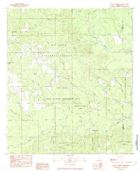
1982 Map of Ramsey Springs
USGS Topo · Published 1982About this map
Black Creek and Red Creek snake across this part of Stone County and George County, defining a landscape largely dedicated to the De Soto National Forest and the Red Creek State Wildlife Management Area. Small rural communities like Ramsey Springs, Ruble, and Moore Crossing serve as anchor points amidst the dense timberlands and creek bottoms. This 1982 provisional survey reveals the legacy of the regional timber industry through an Old RR Grade and the presence of the University of Mississippi Forest. For those researching local family history, several small burial grounds are identified, including Whittington Cem, Hickman Cem, and O'Neal Cem, often located near crossroads and country churches like New Zion Ch. The mapping of small tributaries such as Sandy Creek and Indian Camp Br provides a clear view of the drainage patterns essential to this Gulf Coastal Plain environment.
Find a feature on this map
33 named features on this map. Tap any name to fly to it.
Don’t see what you’re looking for? This feature index may not catch every label — zoom into the map to look around manually.
Map Details
Editions of this 1982 Ramsey Springs Map
This is the sole edition of this map. No revisions or reprints were ever made.
Other maps of this area

1947 · Wiggins
USGS Topo · 1:62,500

1947 · Benndale
USGS Topo · 1:62,500

1949 · Wiggins
USGS Topo · 1:62,500

1949 · Benndale
USGS Topo · 1:62,500

1953 · Mobile
USGS Topo · 1:250,000

1954 · Vestry
USGS Topo · 1:62,500

1954 · McHenry
USGS Topo · 1:62,500

1957 · Mobile
USGS Topo · 1:250,000

1960 · Mobile
USGS Topo · 1:250,000

1963 · Mobile
USGS Topo · 1:250,000