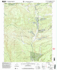
2002 Map of Rancho Del Chaparral
USGS Topo · Published 2003About this map
Sierra Nacimiento and the Nacimiento Mountains dominate this high-altitude landscape within the Santa Fe National Forest. This 2002 revision of earlier 1960s surveys captures a region defined by complex drainage systems and significant land grants, notably the Cañon de San Diego Grant. The settlement of Rancho del Chaparral is positioned in the southern reaches near Ojitos Spring, while a lone School stands further north near the banks of Section Canyon.
Find a feature on this map
50 named features on this map. Tap any name to fly to it.
Don’t see what you’re looking for? This feature index may not catch every label — zoom into the map to look around manually.
Map Details
Editions of this 2002 Rancho Del Chaparral Map
This is the sole edition of this map. No revisions or reprints were ever made.
Other maps of this area

1890 · Jemes
USGS Topo · 1:125,000

1892 · Jemes
USGS Topo · 1:125,000

1909 · Gallina
USGS Topo · 1:125,000

1937 · Jemez Springs
USGS Topo · 1:48,000

1939 · La Ventana
USGS Topo · 1:62,500

1940 · Cuba
USGS Topo · 1:62,500

1943 · Cuba
USGS Topo · 1:62,500

1943 · La Ventana
USGS Topo · 1:62,500

1944 · Jemez Springs
USGS Topo · 1:62,500

1952 · Jemez Springs
USGS Topo · 1:62,500