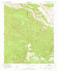
1943 Map of Rancho Nuevo Creek
USGS Topo · Published 1973About this map
The Cuyama River winds through the northern reaches of the Los Padres National Forest in this 1943 survey, marking the arid transition between high ridges and river valley. This interior wilderness, spanning the Santa Barbara and Ventura County line, is defined by an intricate network of drainage systems such as Rancho Nuevo Creek and Tinta Creek. A single educational outpost, the Apache Sch, sits near the mouth of Apache Canyon, suggesting the sparse, dispersed settlement pattern of the canyon lands during the early 1940s. The terrain is punctuated by distinctive topographic landmarks like Morro Hill and the prominent Lizard Head ridge, while small-scale water infrastructure is represented by a lone Windmill positioned in the southern backcountry. These features reflect a landscape used for rangeland and seasonal transit before modern development altered the regional road networks.
Find a feature on this map
17 named features on this map. Tap any name to fly to it.
Don’t see what you’re looking for? This feature index may not catch every label — zoom into the map to look around manually.
Map Details
Editions of this 1943 Rancho Nuevo Creek Map
3 editions found
Other maps of this area

1902 · Santa Ynez
USGS Topo · 1:125,000

1903 · Mt. Pinos
USGS Topo · 1:125,000

1905 · Santa Ynez
USGS Topo · 1:125,000

1942 · Wheeler Springs
USGS Topo · 1:24,000

1943 · Rancho Nuevo Creek
USGS Topo · 1:24,000

1943 · Old Man Mountain
USGS Topo · 1:24,000

1943 · Apache Canyon
USGS Topo · 1:24,000

1943 · Cuyama Peak
USGS Topo · 1:24,000

1943 · Reyes Peak
USGS Topo · 1:24,000

1943 · Wheeler Springs
USGS Topo · 1:24,000