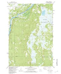
1983 Map of Randall
USGS Topo · Published 1984About this map
The St Croix River defines the western edge of this landscape, marking the state boundary between Minnesota and Wisconsin. This 1980s-era mapping of the river corridor highlights the Sunrise Ferry Riverway and the protected lands of Governor Knowles State Forest. The interior is characterized by a dense network of marshes and waterways, including the Fish Lake State Wildlife Area and Rock Marsh State Wildlife Management Area, where a Lookout Tower stands as a distinct landmark. Small rural settlements and community focal points such as Randall, Benson, and the Pleasant Prairie Ch appear alongside family-named roads like Stolte Road and Alstad Rd. These labels offer a detailed view of the regional geography before modern development, preserving the locations of local landmarks like the Baker settlement and various Cem sites found throughout the township of Anderson.
Find a feature on this map
39 named features on this map. Tap any name to fly to it.
Don’t see what you’re looking for? This feature index may not catch every label — zoom into the map to look around manually.
Map Details
Editions of this 1983 Randall Map
This is the sole edition of this map. No revisions or reprints were ever made.
Other maps of this area

1950 · Rush City
USGS Topo · 1:48,000

1950 · Grantsburg
USGS Topo · 1:48,000

1951 · Milltown
USGS Topo · 1:48,000

1953 · Stillwater
USGS Topo · 1:250,000

1955 · Rush City
USGS Topo · 1:62,500

1955 · Milltown
USGS Topo · 1:62,500

1955 · Stillwater
USGS Topo · 1:250,000

1958 · Stillwater
USGS Topo · 1:250,000

1961 · Pine City
USGS Topo · 1:62,500

1962 · Grantsburg
USGS Topo · 1:62,500