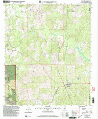
2002 Map of Randolph
USGS Topo · Published 2003About this map
Randolph serves as the primary settlement on this landscape, situated near the headwaters of Oakmulgee Creek and Beaverdam Creek. The topography reflects a rural Alabama interior at the turn of the 21st century, where timberlands and national forest holdings define the geography. Portions of the Talladega National Forest border the western edge of the sheet, providing a contrast to the clusters of local institutions found in the small communities.
Find a feature on this map
19 named features on this map. Tap any name to fly to it.
Don’t see what you’re looking for? This feature index may not catch every label — zoom into the map to look around manually.
Map Details
Editions of this 2002 Randolph Map
This is the sole edition of this map. No revisions or reprints were ever made.
Other maps of this area

1890 · Bessemer
USGS Topo · 1:125,000

1891 · Clanton
USGS Topo · 1:125,000

1892 · Bessemer
USGS Topo · 1:125,000

1899 · Brookwood
USGS Topo · 1:125,000

1910 · Montevallo
USGS Topo · 1:62,500

1934 · Blocton
USGS Topo · 1:48,000

1940 · Blocton
USGS Topo · 1:62,500

1953 · Montgomery
USGS Topo · 1:250,000

1953 · Birmingham
USGS Topo · 1:250,000

1956 · Birmingham
USGS Topo · 1:250,000