
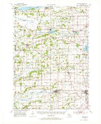
1955 Map of Randolph
USGS Topo · Published 1956About this map
Welsh Prairie and the surrounding farmland of southern Wisconsin define this mid-century landscape, where the Chicago Milwaukee St Paul and Pacific railroad serves the established hubs of Randolph and Cambria. The area is characterized by a dense network of one-room schoolhouses, including Dantz Tavern Sch and Slab Sch, which speak to the rural social structure of the era. To the north, the Grand River and Fox River systems feed into Puckaway Lake, while the historic Military Road cuts through Kingston.
Find a feature on this map
62 named features on this map. Tap any name to fly to it.
Don’t see what you’re looking for? This feature index may not catch every label — zoom into the map to look around manually.
Map Details
Editions of this 1955 Randolph Map
2 editions found
Other maps of this area

1901 · Poynette
USGS Topo · 1:62,500

1902 · Portage
USGS Topo · 1:62,500

1915 · Neshkoro
USGS Topo · 1:48,000

1916 · Ripon
USGS Topo · 1:48,000

1918 · Neshkoro
USGS Topo · 1:62,500

1918 · Ripon
USGS Topo · 1:62,500

1955 · Columbus
USGS Topo · 1:62,500

1955 · Beaver Dam
USGS Topo · 1:62,500

1955 · Fox Lake
USGS Topo · 1:62,500

1956 · Ripon
USGS Topo · 1:62,500