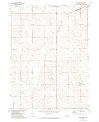
1971 Map of Randolph SW
USGS Topo · Published 1985About this map
Yankton Slough and Middle Logan Creek drain the undulating prairie of northeast Nebraska in this early 1970s landscape. This rural section of Pierce County reflects a traditional agricultural settlement pattern defined by isolated farmsteads and essential local landmarks. The Burlington Northern railroad cuts through the northern corner of the quadrangle, serving as a primary transit artery for the region's commodities. For those researching local history, the map provides precise locations for community centers that are often lost over time, including School No 46 and West Hill Sch. The Rose Hill Cem stands as a significant site for genealogical study, while the presence of a Substation indicates the encroaching infrastructure of the mid-20th century power grid into this quiet corner of the plains.
Find a feature on this map
7 named features on this map. Tap any name to fly to it.
Don’t see what you’re looking for? This feature index may not catch every label — zoom into the map to look around manually.
Map Details
Editions of this 1971 Randolph SW Map
2 editions found
Other maps of this area

1955 · Sioux City
USGS Topo · 1:250,000

1958 · Sioux City
USGS Topo · 1:250,000

1959 · Sioux City
USGS Topo · 1:250,000

1963 · Osmond
USGS Topo · 1:24,000

1963 · Wee Town
USGS Topo · 1:24,000
1963 · Pierce
USGS Topo · 1:24,000

1963 · Norfolk NE
USGS Topo · 1:24,000

1971 · Wausa
USGS Topo · 1:24,000

1971 · Randolph South
USGS Topo · 1:24,000

1971 · Randolph North
USGS Topo · 1:24,000