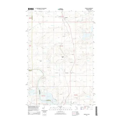
2014 Map of Randville
USGS Topo · Published 2014About this map
The Menominee River serves as the prominent natural boundary between Michigan and Wisconsin, anchoring a landscape defined by an intricate network of glacial lakes and northern forests. In the northern reaches of Florence County and neighboring Dickinson County, small settlements like Randville and Merriman sit along the primary north-south corridor, while Granite Bluff marks the transition toward the waterway. The region is notable for the Spread Eagle Chain of Lakes, a complex of water bodies including East Lake, South Lake, and Long Lake that dominate the southwestern corner. Local infrastructure like Lilienthal Airport and a grid of rural roads such as Peavy Falls Rd and Merriman W Rd provide access to the numerous water features, including the Little Badwater Lake and the winding W Br Sturgeon River.
Find a feature on this map
61 named features on this map. Tap any name to fly to it.
Don’t see what you’re looking for? This feature index may not catch every label — zoom into the map to look around manually.
Map Details
Editions of this 2014 Randville Map
This is the sole edition of this map. No revisions or reprints were ever made.
Other maps of this area

1899 · Sagola
USGS Topo · 1:62,500

1939 · Iron Mountain
USGS Topo · 1:48,000

1941 · Iron Mountain
USGS Topo · 1:48,000

1947 · Iron Mountain
USGS Topo · 1:48,000

1947 · Lake Mary
USGS Topo · 1:24,000
1949 · Commonwealth
USGS Topo · 1:24,000

1954 · Iron Mountain
USGS Topo · 1:250,000

1954 · Escanaba
USGS Topo · 1:250,000

1955 · Norway
USGS Topo · 1:24,000

1955 · Norway
USGS Topo · 1:62,500