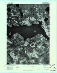
1977 Map of Rangeley
USGS Topo · Published 1983About this map
Rangeley sits at the northeastern reach of Rangeley Lake in this late-1970s orthophotoquad, which uses aerial photography to capture the precise texture of the Franklin County landscape. The settlement of Mingo Springs is visible on the northern shore, where the road network winds through a mix of dense forest and cleared clearings. To the south, the terrain rises toward Beaver Mountain, while the winding course of South Bog Stream drains into the lake's southern basin. The imagery provides a clear view of the water's edge at Dodge Pond and the distant eastern tip of Mooselookmeguntic Lake. This orthophoto format is particularly useful for identifying modern land use patterns, docks, and exact forest boundaries that traditional topographic maps often generalize with symbols.
Find a feature on this map
7 named features on this map. Tap any name to fly to it.
Don’t see what you’re looking for? This feature index may not catch every label — zoom into the map to look around manually.
Map Details
Editions of this 1977 Rangeley Map
This is the sole edition of this map. No revisions or reprints were ever made.
Other maps of this area

1931 · Cupsuptic
USGS Topo · 1:48,000

1932 · Kennebago Lake
USGS Topo · 1:48,000

1933 · Rangeley
USGS Topo · 1:48,000

1934 · Cupsuptic
USGS Topo · 1:62,500

1935 · Kennebago Lake
USGS Topo · 1:62,500

1935 · Cupsuptic
USGS Topo · 1:62,500

1936 · Kennebago Lake
USGS Topo · 1:62,500

1939 · Rangeley
USGS Topo · 1:62,500

1940 · Oquossoc
USGS Topo · 1:62,500

1942 · Oquossoc
USGS Topo · 1:62,500
Featured Places
- Rangeley, ME
- Dallas Plantation, ME
- Rangeley Plantation, ME
- Sandy River Plantation, ME
- Franklin County, ME