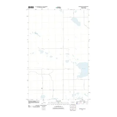
2011 Map of Rangeley NE
USGS Topo · Published 2011About this map
Smoky Lake dominates the eastern landscape of this McHenry County region, highlighting a prairie pothole environment characterized by numerous small, scattered wetlands and depressions. The terrain is relatively uniform, punctuated by the localized elevation of Bald Butte in the southwest. A rigid section-line road network, including 13th Ave NE and 50th St NE, organizes the rural space into the classic grid of the Great Plains, facilitating travel across the open country. Fresh Water Lake and the smaller Duckshire Lake offer further evidence of the area's glacial history and unique hydrology. This map provides a clear view of the mid-century agricultural landscape and the natural water features that define North Dakota's central plains.
Find a feature on this map
17 named features on this map. Tap any name to fly to it.
Don’t see what you’re looking for? This feature index may not catch every label — zoom into the map to look around manually.
Map Details
Editions of this 2011 Rangeley NE Map
This is the sole edition of this map. No revisions or reprints were ever made.
Other maps of this area

1950 · Towner
USGS Topo · 1:24,000

1954 · Berwick
USGS Topo · 1:24,000

1954 · Towner SE
USGS Topo · 1:24,000

1954 · Minot
USGS Topo · 1:250,000

1955 · Rangeley NW
USGS Topo · 1:24,000

1955 · Rangeley NE
USGS Topo · 1:24,000

1957 · Rangeley SE
USGS Topo · 1:24,000

1957 · Rangeley
USGS Topo · 1:24,000

1958 · Minot
USGS Topo · 1:250,000
1958 · Balta NW
USGS Topo · 1:24,000