
1950 Map of Towner
USGS Topo · Published 1950About this map
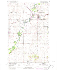
The Souris River carves a winding path through the heart of the McHenry County landscape, its meanders framed by a system of Levees and the Eaton Dam. Centered on the town of Towner, this 1950 survey documents a transition in local transportation and infrastructure as the Great Northern railroad corridors and the Towner Airport served as vital connections for the rural community. The township of Newport and the surrounding plains are dotted with agricultural markers like the Windmill and local institutions such as School No 1. Significant elevation changes are noted at Cooperdahl Hill to the south, while the proximity of Gravel Pits and a central Water Tank indicate the small-town industrial needs of the mid-century era. This record provides a clear look at the area's development before modern river management and highway expansions altered the historic footprint of the valley.
Find a feature on this map
18 named features on this map. Tap any name to fly to it.
Don’t see what you’re looking for? This feature index may not catch every label — zoom into the map to look around manually.
Map Details
Editions of this 1950 Towner Map
2 editions found
Other maps of this area

1949 · Denbigh
USGS Topo · 1:24,000

1949 · Bantry
USGS Topo · 1:24,000

1950 · Karlsruhe NE
USGS Topo · 1:24,000

1950 · Towner NW
USGS Topo · 1:24,000

1950 · Denbigh
USGS Topo · 1:24,000

1950 · Bantry
USGS Topo · 1:24,000

1954 · Towner NE
USGS Topo · 1:24,000

1954 · Towner SE
USGS Topo · 1:24,000

1954 · Minot
USGS Topo · 1:250,000

1955 · Rangeley NW
USGS Topo · 1:24,000