
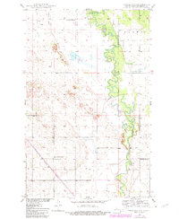
1950 Map of Towner NW
USGS Topo · Published 1950About this map
The Souris River meanders in tight oxbow loops across this McHenry County landscape, creating a distinct riparian corridor through the plains. The northern portion of the river's path is preserved within the Lower Souris National Wildlife Refuge, where a levee system manages the seasonal waters. The rural character of the mid-century is defined by a network of numbered district schools that once served the scattered farming families, including Poplar Grove Sch No 1, Mouse River Sch No 2, and Red Cross Sch No 1. Transport and infrastructure are represented by the diagonal line of the Great Northern railroad, which cuts across the southwest corner. For genealogists, the presence of the Mouse River Cem near Mouse River Sch No 1 provides a specific point of interest for tracing early residents of this prairie community.
Find a feature on this map
10 named features on this map. Tap any name to fly to it.
Don’t see what you’re looking for? This feature index may not catch every label — zoom into the map to look around manually.
Map Details
Editions of this 1950 Towner NW Map
2 editions found
Other maps of this area

1949 · Denbigh
USGS Topo · 1:24,000

1949 · Bantry
USGS Topo · 1:24,000

1950 · Upham SE
USGS Topo · 1:24,000

1950 · Towner
USGS Topo · 1:24,000

1950 · Willow City SW
USGS Topo · 1:24,000

1950 · Denbigh
USGS Topo · 1:24,000

1950 · Bantry
USGS Topo · 1:24,000

1954 · Towner NE
USGS Topo · 1:24,000

1954 · Willow City
USGS Topo · 1:24,000

1954 · Towner SE
USGS Topo · 1:24,000