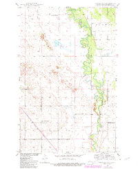
1950 Map of Towner NW
USGS Topo · Published 1981About this map
The Souris River meanders sharply through this McHenry County landscape, its tight oxbows and flood-prone banks protected in the north by the J. Clark Salyer National Wildlife Refuge. This mid-century survey reveals a rural society organized around small district schoolhouses and isolated homesteads. Landmarks such as Poplar Grove Sch No 1, Mouse River Sch No 1, and Red Cross Sch No 1 indicate the localized nature of education before consolidation.
Find a feature on this map
10 named features on this map. Tap any name to fly to it.
Don’t see what you’re looking for? This feature index may not catch every label — zoom into the map to look around manually.
Map Details
Editions of this 1950 Towner NW Map
2 editions found
Other maps of this area

1949 · Denbigh
USGS Topo · 1:24,000

1949 · Bantry
USGS Topo · 1:24,000

1950 · Towner NW
USGS Topo · 1:24,000

1950 · Upham SE
USGS Topo · 1:24,000

1950 · Towner
USGS Topo · 1:24,000

1950 · Willow City SW
USGS Topo · 1:24,000

1950 · Denbigh
USGS Topo · 1:24,000

1950 · Bantry
USGS Topo · 1:24,000

1954 · Towner NE
USGS Topo · 1:24,000

1954 · Willow City
USGS Topo · 1:24,000