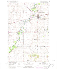
1950 Map of Towner
USGS Topo · Published 1981About this map
Towner serves as the focal point of this North Dakota landscape, situated where the Burlington Northern railroad lines intersect north of the winding Souris River. The map captures the town's infrastructure during the mid-20th century, featuring a Water Tank, a substation, and the Towner Airport to the northeast. Beyond the residential grid, the geography is defined by the river's tight meanders through the Newport township area, controlled in part by the Eaton Dam. To the south, the terrain rises toward Cooperdahl Hill, where School No 1 once served the rural community. This survey provides a record of the Missouri River Basin development era, documenting the essential water management and transportation systems that supported McHenry County agriculture and commerce before later 20th-century shifts.
Find a feature on this map
19 named features on this map. Tap any name to fly to it.
Don’t see what you’re looking for? This feature index may not catch every label — zoom into the map to look around manually.
Map Details
Editions of this 1950 Towner Map
2 editions found
Other maps of this area

1949 · Denbigh
USGS Topo · 1:24,000

1949 · Bantry
USGS Topo · 1:24,000

1950 · Karlsruhe NE
USGS Topo · 1:24,000

1950 · Towner NW
USGS Topo · 1:24,000

1950 · Towner
USGS Topo · 1:24,000

1950 · Denbigh
USGS Topo · 1:24,000

1950 · Bantry
USGS Topo · 1:24,000

1954 · Towner NE
USGS Topo · 1:24,000

1954 · Towner SE
USGS Topo · 1:24,000

1954 · Minot
USGS Topo · 1:250,000