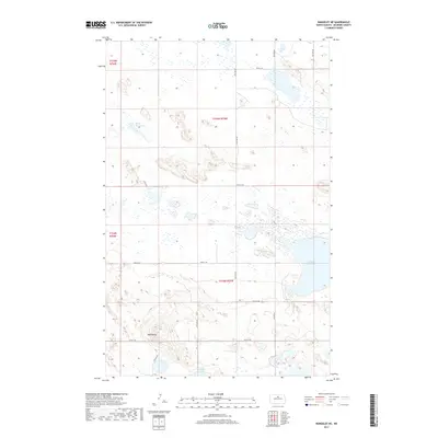
2017 Map of Rangeley NE
USGS Topo · Published 2017About this map
Smoky Lake and a high concentration of ephemeral wetlands define this prairie landscape in McHenry County. The terrain is relatively flat, punctuated only by Bald Butte, a localized rise that provides a vantage point over the surrounding section lines. The map reveals a land divided by a rigid grid of rural roads, including 57th St NE and 14th Ave NE, which navigate around numerous small water bodies. Aside from the larger basins like Fresh Water Lake and Duckshire Lake, the area is densely pockmarked with unnamed prairie potholes. This hydrographic pattern suggests a landscape primarily dedicated to livestock grazing or wildlife habitat rather than dense residential development, maintaining the quiet character of the North Dakota plains.
Find a feature on this map
18 named features on this map. Tap any name to fly to it.
Don’t see what you’re looking for? This feature index may not catch every label — zoom into the map to look around manually.
Map Details
Editions of this 2017 Rangeley NE Map
This is the sole edition of this map. No revisions or reprints were ever made.
Other maps of this area

1950 · Towner
USGS Topo · 1:24,000

1954 · Berwick
USGS Topo · 1:24,000

1954 · Towner SE
USGS Topo · 1:24,000

1954 · Minot
USGS Topo · 1:250,000

1955 · Rangeley NW
USGS Topo · 1:24,000

1955 · Rangeley NE
USGS Topo · 1:24,000

1957 · Rangeley SE
USGS Topo · 1:24,000

1957 · Rangeley
USGS Topo · 1:24,000

1958 · Minot
USGS Topo · 1:250,000
1958 · Balta NW
USGS Topo · 1:24,000