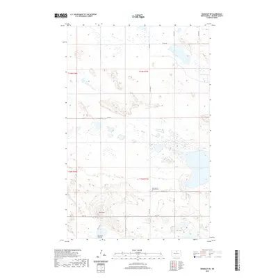
2020 Map of Rangeley NE
USGS Topo · Published 2020About this map
Saint Johns of Blumenfeld Cem and Saint John of Blumenfeld South Cem sit within this portion of McHenry County, documenting the cultural history of this rural prairie landscape. The terrain is defined by glacial depressions and distinct elevations, most notably the peak at Bald Butte in the southwestern quadrant. To the east, the basin of Smoky Lake marks the hydrological low point, surrounded by a network of sectional roads like 50th St NE and 13th Ave NE. The township boundaries of t155n r75w and t154n r75w intersect here, revealing the grid-based land management of the North Dakota plains. The map illustrates a high density of small wetlands and ephemeral ponds, characteristic of the pothole region, which influence the winding paths of local connector roads.
Find a feature on this map
16 named features on this map. Tap any name to fly to it.
Don’t see what you’re looking for? This feature index may not catch every label — zoom into the map to look around manually.
Map Details
Editions of this 2020 Rangeley NE Map
This is the sole edition of this map. No revisions or reprints were ever made.
Other maps of this area

1950 · Towner
USGS Topo · 1:24,000

1954 · Berwick
USGS Topo · 1:24,000

1954 · Towner SE
USGS Topo · 1:24,000

1954 · Minot
USGS Topo · 1:250,000

1955 · Rangeley NW
USGS Topo · 1:24,000

1955 · Rangeley NE
USGS Topo · 1:24,000

1957 · Rangeley SE
USGS Topo · 1:24,000

1957 · Rangeley
USGS Topo · 1:24,000

1958 · Minot
USGS Topo · 1:250,000
1958 · Balta NW
USGS Topo · 1:24,000