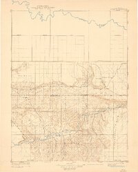
1910 Map of Rangely
USGS Topo · Published 1939About this map
Rangely and the surrounding high desert of Northwest Colorado appear here during a period of early surveying by Hoyt S. Gale. This 1907 reconnaissance-style survey, reprinted from a geologic base map, focuses on the drainage systems of the White River and the Yampa River. The landscape is dominated by the broad expanse of Raven Park and the prominent Cathedral Bluffs to the east. Sparse settlements like Angora, Boxelder, and Three Springs dot the terrain, which is otherwise defined by dry washes and gulches such as Stinking Creek and Fletcher Gulch. The map captures the region before extensive modern development, clearly showing the Routt Co Rio Blanco Co Boundary Line and the original township grids established from the southern Base Line.
Find a feature on this map
16 named features on this map. Tap any name to fly to it.
Don’t see what you’re looking for? This feature index may not catch every label — zoom into the map to look around manually.
Map Details
Editions of this 1910 Rangely Map
2 editions found
Other maps of this area

1885 · East Tavaputs
USGS Topo · 1:250,000

1885 · Ashley
USGS Topo · 1:250,000

1907 · Rangely
USGS Topo · 1:125,000

1907 · Jensen
USGS Topo · 1:125,000

1907 · White River
USGS Topo · 1:125,000

1910 · Jensen
USGS Topo · 1:125,000

1910 · White River
USGS Topo · 1:125,000

1910 · Rangely
USGS Topo · 1:125,000

1952 · Wolf Ridge
USGS Topo · 1:24,000

1954 · Hells Canyon
USGS Topo · 1:24,000