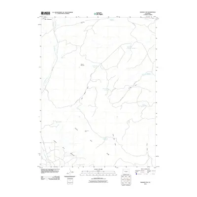
2010 Map of Rangely NE
USGS Topo · Published 2010About this map
Coal Oil Basin dominates this portion of Northwest Colorado, revealing a landscape defined by natural resource extraction and water management. The area is marked by numerous industrial landmarks such as the Blue Flame Mine in the north and the White River Mine near the center, highlighting the region's mining heritage. This arid terrain necessitates a network of man-made catchments, including Red Wash Reservoir Number 1, Halandras Reservoir Number 1, and Raven Basin Reservoir, which dot the drainages of Stinking Water Creek and Dead Dog Draw. The topography rises from these basins to the heights of Blue Mountain and the curiously named Spooky Mountain. Movement through this remote country is facilitated by a grid of rural routes like County RD 96 and County HWY 1, connecting the isolated mine sites and reservoirs across the rugged Moffat County landscape.
Find a feature on this map
24 named features on this map. Tap any name to fly to it.
Don’t see what you’re looking for? This feature index may not catch every label — zoom into the map to look around manually.
Map Details
Editions of this 2010 Rangely NE Map
This is the sole edition of this map. No revisions or reprints were ever made.
Other maps of this area

1907 · Rangely
USGS Topo · 1:125,000

1910 · Rangely
USGS Topo · 1:125,000

1954 · Vernal
USGS Topo · 1:250,000

1958 · Vernal
USGS Topo · 1:250,000

1960 · Vernal
USGS Topo · 1:250,000

1962 · Lazy Y Point
USGS Topo · 1:24,000

1962 · Rangely NE
USGS Topo · 1:24,000
1962 · Rangely
USGS Topo · 1:24,000

1962 · Cactus Reservoir
USGS Topo · 1:24,000
1962 · Mellen Hill
USGS Topo · 1:24,000