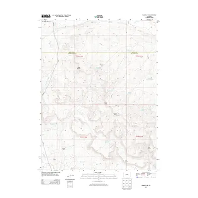
2013 Map of Rangely NE
USGS Topo · Published 2013About this map
Blue Mountain dominates the northern landscape of this Northwestern Colorado quadrangle, where the high desert terrain of the Moffat and Rio Blanco county line transitions into a network of drainages and industrial development. The southern portion of the map is defined by the Rangely Oil Field, showcasing the infrastructure of the energy industry in the Coal Oil Basin. The topography is marked by distinctive features such as Spooky Mountain and the Coal Oil Rim, which overlooks various gulches and draws. Water management is a central theme of the landscape, with numerous small reservoirs like Raven Basin Reservoir, Burning Mine Reservoir, and Skyline Reservoir scattered across the arid terrain to catch runoff from seasonal watercourses like Stinking Water Creek and Willow Creek. This network of reservoirs and industrial sites reflects the intensive human use of the land for resource extraction and ranching in a dry climate.
Find a feature on this map
30 named features on this map. Tap any name to fly to it.
Don’t see what you’re looking for? This feature index may not catch every label — zoom into the map to look around manually.
Map Details
Editions of this 2013 Rangely NE Map
This is the sole edition of this map. No revisions or reprints were ever made.
Other maps of this area

1907 · Rangely
USGS Topo · 1:125,000

1910 · Rangely
USGS Topo · 1:125,000

1954 · Vernal
USGS Topo · 1:250,000

1958 · Vernal
USGS Topo · 1:250,000

1960 · Vernal
USGS Topo · 1:250,000

1962 · Lazy Y Point
USGS Topo · 1:24,000

1962 · Rangely NE
USGS Topo · 1:24,000
1962 · Rangely
USGS Topo · 1:24,000

1962 · Cactus Reservoir
USGS Topo · 1:24,000
1962 · Mellen Hill
USGS Topo · 1:24,000