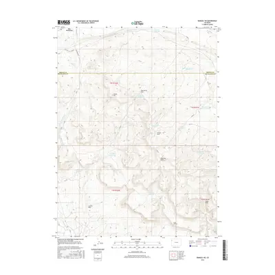
2016 Map of Rangely NE
USGS Topo · Published 2016About this map
Blue Mountain dominates the northern skyline of this high-desert landscape on the border of Moffat and Rio Blanco counties. The terrain is defined by a series of drainages and seasonal water management features, including the Victory Stock Driveway which cuts across the northwest corner. To the south, the land falls away into the Coal Oil Basin, framed by the distinct Coal Oil Rim. This area is heavily shaped by water storage efforts in a semi-arid climate, evidenced by the numerous named catchments such as Raven Basin Reservoir, Skyline Reservoir, and Rock Shale Reservoir. Significant erosion patterns are marked by named features like Scullion Gulch, Dead Dog Draw, and Nate Spring Draw. The map reveals a land utilized for resource management and livestock movement, with Stinking Water Cr and Willow Cr threading through the elevations of Spooky Mtn.
Find a feature on this map
31 named features on this map. Tap any name to fly to it.
Don’t see what you’re looking for? This feature index may not catch every label — zoom into the map to look around manually.
Map Details
Editions of this 2016 Rangely NE Map
This is the sole edition of this map. No revisions or reprints were ever made.
Other maps of this area

1907 · Rangely
USGS Topo · 1:125,000

1910 · Rangely
USGS Topo · 1:125,000

1954 · Vernal
USGS Topo · 1:250,000

1958 · Vernal
USGS Topo · 1:250,000

1960 · Vernal
USGS Topo · 1:250,000

1962 · Lazy Y Point
USGS Topo · 1:24,000

1962 · Rangely NE
USGS Topo · 1:24,000
1962 · Rangely
USGS Topo · 1:24,000

1962 · Cactus Reservoir
USGS Topo · 1:24,000
1962 · Mellen Hill
USGS Topo · 1:24,000