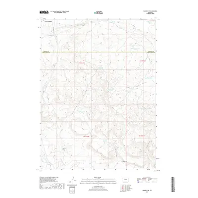
2019 Map of Rangely NE
USGS Topo · Published 2019About this map
Blue Mountain dominates the northern skyline of this high-desert landscape in Northwestern Colorado, where the border between Moffat County and Rio Blanco County bisects the terrain. This area is defined by a sophisticated network of small-scale water management, evidenced by numerous named catchment points such as Rock Shale Reservoir, Lincoln Reservoir, and the Fossil Reservoir. These features, along with the Victory Stock Driveway, reveal a landscape shaped by the practical needs of livestock and resource extraction. Significant landforms like Spooky Mtn and the Coal Oil Rim overlook deep drainage systems including Scullion Gulch and Nate Spring Draw. The intricate topography of the Coal Oil Basin and various named draws suggest a complex geological history where water is both a scarce resource and the primary architect of the land.
Find a feature on this map
32 named features on this map. Tap any name to fly to it.
Don’t see what you’re looking for? This feature index may not catch every label — zoom into the map to look around manually.
Map Details
Editions of this 2019 Rangely NE Map
This is the sole edition of this map. No revisions or reprints were ever made.
Other maps of this area

1907 · Rangely
USGS Topo · 1:125,000

1910 · Rangely
USGS Topo · 1:125,000

1954 · Vernal
USGS Topo · 1:250,000

1958 · Vernal
USGS Topo · 1:250,000

1960 · Vernal
USGS Topo · 1:250,000

1962 · Lazy Y Point
USGS Topo · 1:24,000

1962 · Rangely NE
USGS Topo · 1:24,000
1962 · Rangely
USGS Topo · 1:24,000

1962 · Cactus Reservoir
USGS Topo · 1:24,000
1962 · Mellen Hill
USGS Topo · 1:24,000