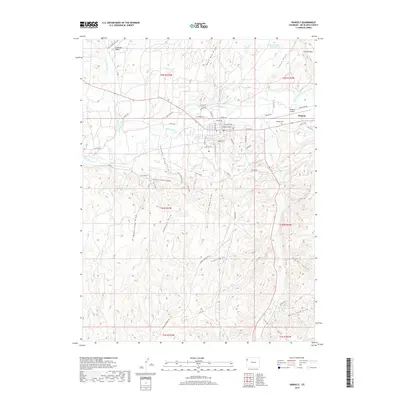
2019 Map of Rangely
USGS Topo · Published 2019About this map
Rangely occupies the central valley along the White River, serving as a hub for the surrounding arid terrain of Rio Blanco County. The town grid is clearly defined by streets such as East Main Street and Denver Avenue, with the Rangely Cemetery and Rangely Airport situated on the eastern outskirts. This 2019 survey illustrates a landscape deeply shaped by drainage patterns and resource extraction, characterized by numerous draws and basins including Coal Oil Basin and Coal Mine Draw. The local geography is marked by the complex intersection of the White River and Douglas Creek, with named features like Red Hill Canyon and Rocky Ford Draw defining the southern and eastern horizons. The map also captures specialized transport routes like the Poison Ivy Bypass, reflecting the area's ongoing activity in industrial or recreational transit through the high desert draws.
Find a feature on this map
61 named features on this map. Tap any name to fly to it.
Don’t see what you’re looking for? This feature index may not catch every label — zoom into the map to look around manually.
Map Details
Editions of this 2019 Rangely Map
This is the sole edition of this map. No revisions or reprints were ever made.
Other maps of this area

1907 · Rangely
USGS Topo · 1:125,000

1910 · Rangely
USGS Topo · 1:125,000

1954 · Vernal
USGS Topo · 1:250,000

1956 · Grand Junction
USGS Topo · 1:250,000

1958 · Vernal
USGS Topo · 1:250,000

1959 · Grand Junction
USGS Topo · 1:250,000

1960 · Vernal
USGS Topo · 1:250,000

1960 · Grand Junction
USGS Topo · 1:250,000

1962 · Grand Junction
USGS Topo · 1:250,000

1962 · Rangely NE
USGS Topo · 1:24,000