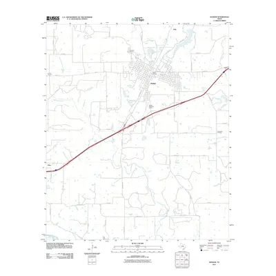
2011 Map of Ranger
USGS Topo · Published 2011About this map
Ranger serves as the primary hub of this Eastland County region, situated along a prominent transit corridor that includes E Loop 254 and W Loop 254. The landscape is defined by the drainage of Colony Creek and its northern branch, alongside smaller water features such as Hagaman Lake and the isolated Winsett Spring. Smaller community settlements like Olden to the southwest and Tiffin to the north provide localized context to the ranching and municipal roads that crisscross the area.
Find a feature on this map
49 named features on this map. Tap any name to fly to it.
Don’t see what you’re looking for? This feature index may not catch every label — zoom into the map to look around manually.
Map Details
Editions of this 2011 Ranger Map
This is the sole edition of this map. No revisions or reprints were ever made.
Other maps of this area

1890 · Breckenridge
USGS Topo · 1:125,000

1894 · Eastland
USGS Topo · 1:125,000

1954 · Abilene
USGS Topo · 1:250,000

1958 · Abilene
USGS Topo · 1:250,000

1966 · Kokomo
USGS Topo · 1:24,000
1966 · Desdemona
USGS Topo · 1:24,000

1966 · Carbon
USGS Topo · 1:24,000
1966 · Bear Mountain
USGS Topo · 1:24,000

1966 · Eastland
USGS Topo · 1:24,000

1966 · Ranger
USGS Topo · 1:24,000