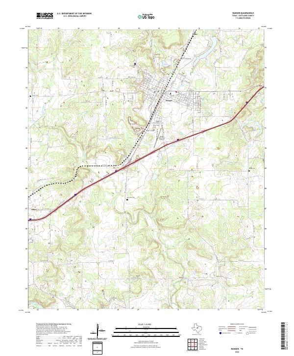
2022 Map of Ranger
USGS Topo · Published 2022About this map
Ranger serves as the focal point of this Eastland County landscape, where the modern transport corridor of Interstate 20 bisects a region long defined by its creeks and ranching roads. The area's history is anchored by several burial grounds, including the centrally located Pioneer Cem and Evergreen Cem near the town center, and the more isolated Merriman Cem to the south. These landmarks, along with Ranger College and the Ranger Municipal Airport, illustrate the community's development from a frontier railroad town into a regional educational and transit hub. To the west, the smaller settlement of Olden sits along the road network, while the northern reaches transition into the drainage basin of Palo Pinto Cr. The southern portion of the map is defined by the winding course of the Leon River and Lick Br, highlighting the importance of water sources like Winsett Spring and Hodges Lake in this part of North Central Texas.
Find a feature on this map
102 named features on this map. Tap any name to fly to it.
Don’t see what you’re looking for? This feature index may not catch every label — zoom into the map to look around manually.
Map Details
Editions of this 2022 Ranger Map
This is the sole edition of this map. No revisions or reprints were ever made.
Other maps of this area

1890 · Breckenridge
USGS Topo · 1:125,000

1894 · Eastland
USGS Topo · 1:125,000

1954 · Abilene
USGS Topo · 1:250,000

1958 · Abilene
USGS Topo · 1:250,000

1966 · Kokomo
USGS Topo · 1:24,000
1966 · Desdemona
USGS Topo · 1:24,000

1966 · Carbon
USGS Topo · 1:24,000
1966 · Bear Mountain
USGS Topo · 1:24,000

1966 · Eastland
USGS Topo · 1:24,000

1966 · Ranger
USGS Topo · 1:24,000