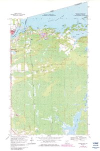
1969 Map of Ranier
USGS Topo · Published 1983About this map
The international border between Canada and the United States runs through the waters of Rainy Lake and the Rainy River on this northern Minnesota survey. The settlement of Ranier serves as a key point of entry where the Duluth Winnipeg and Pacific railroad crosses into Ontario, meeting the Canadian National line at Fort Frances. To the south and east, the landscape transitions into a complex network of wetlands and waterways, including Rat Root Lake and the meandering Rat Root River. Several small clusters of development like Jameson and Falls Junction appear near the rail corridors, while landmarks such as Point-O-Pines Ch and Clarks Park indicate the social hubs of this border community. The presence of a long Winter Trail cutting through the southern marshlands highlights the seasonal adaptations required for transportation in the Koochiching County wilderness.
Find a feature on this map
34 named features on this map. Tap any name to fly to it.
Don’t see what you’re looking for? This feature index may not catch every label — zoom into the map to look around manually.
Map Details
Editions of this 1969 Ranier Map
2 editions found
Other maps of this area

1919 · International Falls
USGS Topo · 1:62,500

1954 · International Falls
USGS Topo · 1:250,000

1957 · International Falls
USGS Topo · 1:250,000

1958 · International Falls
USGS Topo · 1:250,000

1963 · Ranier
USGS Topo · 1:24,000

1969 · Island View
USGS Topo · 1:24,000

1969 · Ericsburg NW
USGS Topo · 1:24,000

1969 · Ericsburg
USGS Topo · 1:24,000

1969 · Ray
USGS Topo · 1:24,000

1969 · Ranier
USGS Topo · 1:24,000