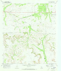
1970 Map of Rankin NE
USGS Topo · Published 1973About this map
The Flat Rock Oil Field defines the northern reaches of this West Texas landscape, where the production of natural resources intersects with a traditional ranching economy. Straddling the boundary of Upton Co and Reagan Co, the map reveals a network of Oil Wells, pipelines, and gravel pits that underscore the industrial activity of the early 1970s. The presence of the Atchison Topeka and Santa Fe railroad through the northern section provided the vital transportation link necessary for moving equipment and extracted materials.
Find a feature on this map
17 named features on this map. Tap any name to fly to it.
Don’t see what you’re looking for? This feature index may not catch every label — zoom into the map to look around manually.
Map Details
Editions of this 1970 Rankin NE Map
This is the sole edition of this map. No revisions or reprints were ever made.
Other maps of this area

1928 · Rankin
USGS Topo · 1:125,000

1954 · San Angelo
USGS Topo · 1:250,000

1958 · San Angelo
USGS Topo · 1:250,000

1965 · San Angelo
USGS Topo · 1:250,000

1970 · Sevenmile Corner SE
USGS Topo · 1:24,000
1970 · Rankin SE
USGS Topo · 1:24,000
1970 · Cedar Canyon
USGS Topo · 1:24,000

1970 · Sevenmile Corner
USGS Topo · 1:24,000

1970 · Garrison Draw
USGS Topo · 1:24,000
1970 · Texon
USGS Topo · 1:24,000