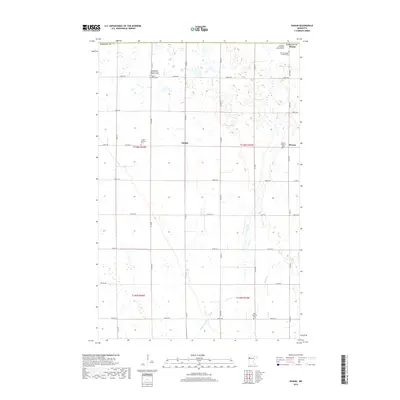
2019 Map of Ranum
USGS Topo · Published 2019About this map
The agricultural landscape of Norman County is defined by a dense network of Lutheran heritage sites and small rural crossroads. Near the central settlement of Sundal, the land is structured by a precise grid of section lines and county roads, reflecting a late-twentieth-century persistence of family farmsteads and local congregations. A striking concentration of historic burial grounds, including the Zion Norwegian Lutheran Cem, Faaberg Norwegian Lutheran Cem, and the uniquely named International Order of Good Templars Cem, provides significant data for genealogists tracing Scandinavian settlement patterns in this part of Minnesota. The topography is largely level, punctuated by water features like Mashaug Cr and the Garden Slough which drain the prairie toward the west. Small community clusters like Rindal and Ranum serve as peripheral markers for this deeply rooted farming district.
Find a feature on this map
40 named features on this map. Tap any name to fly to it.
Don’t see what you’re looking for? This feature index may not catch every label — zoom into the map to look around manually.
Map Details
Editions of this 2019 Ranum Map
This is the sole edition of this map. No revisions or reprints were ever made.
Other maps of this area

1918 · Twin Valley
USGS Topo · 1:62,500

1919 · Valley
USGS Topo · 1:62,500

1952 · Grand Forks
USGS Topo · 1:250,000

1956 · Grand Forks
USGS Topo · 1:250,000

1965 · Fertile
USGS Topo · 1:24,000

1965 · Waukon
USGS Topo · 1:24,000

1965 · Twin Valley
USGS Topo · 1:24,000

1965 · Flaming
USGS Topo · 1:24,000

1966 · Grand Forks
USGS Topo · 1:250,000
1966 · Halverson Lake
USGS Topo · 1:24,000