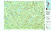
1985 Map of Raquette Lake
USGS Topo · Published 1994About this map
Adirondack Park defines the landscape of this mid-1980s survey, illustrating a vast network of water bodies and ridgelines across Hamilton, Herkimer, and Essex counties. The map centers on the intricate shoreline of Raquette Lake and the connected waters of the Fulton Chain, including Fourth Lake and Seventh Lake. Settlement patterns are sparse, anchored by small hubs like Old Forge and Speculator, while the Penn Central rail line cuts through the western forests near Carter Station.
Find a feature on this map
55 named features on this map. Tap any name to fly to it.
Don’t see what you’re looking for? This feature index may not catch every label — zoom into the map to look around manually.
Map Details
Editions of this 1985 Raquette Lake Map
2 editions found
Other maps of this area

1895 · North Creek
USGS Topo · 1:62,500

1895 · Mt. Marcy
USGS Topo · 1:62,500

1897 · North Creek
USGS Topo · 1:62,500

1897 · Schroon Lake
USGS Topo · 1:62,500

1897 · Remsen
USGS Topo · 1:62,500

1898 · Newcomb
USGS Topo · 1:62,500

1898 · Thirteenth Lake
USGS Topo · 1:62,500

1899 · Indian Lake
USGS Topo · 1:62,500

1900 · Remsen
USGS Topo · 1:62,500

1900 · Canada Lake
USGS Topo · 1:62,500