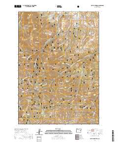
2020 Map of Rastus Mountain
USGS Topo · Published 2020About this map
Whitman National Forest and Malheur National Forest converge in this high-altitude landscape, where the headwaters of Rastus Creek and Long Creek drain a complex terrain of volcanic peaks and basins. The presence of numerous named water sources, such as Johnson Ditch Spring and Broken Top Spring, highlights the critical importance of water management in this high-desert environment. Strategic improvements like the Long Creek Reservoir and Johnson Ditch reflect the ongoing efforts to harness runoff from Rastus Mountain and Bullrun Mountain for local use. For genealogists and historians, the map preserves specific land-use identifiers like Murray Pasture and Koski Basin, alongside distinctive geological features such as the circular depression known as Hole In The Ground and the prominent Waqiima Butte.
Find a feature on this map
75 named features on this map. Tap any name to fly to it.
Don’t see what you’re looking for? This feature index may not catch every label — zoom into the map to look around manually.
Map Details
Editions of this 2020 Rastus Mountain Map
This is the sole edition of this map. No revisions or reprints were ever made.
Other maps of this area

1908 · Ironside Mountain
USGS Topo · 1:125,000

1955 · Canyon City
USGS Topo · 1:250,000

1959 · Canyon City
USGS Topo · 1:250,000

1970 · Flag Prairie
USGS Topo · 1:62,500

1970 · Castle Rock
USGS Topo · 1:62,500
1972 · Hereford
USGS Topo · 1:24,000
1972 · Unity
USGS Topo · 1:24,000
1972 · Bullrun Rock
USGS Topo · 1:24,000
1972 · Rail Gulch
USGS Topo · 1:24,000
1972 · Rastus Mtn
USGS Topo · 1:24,000