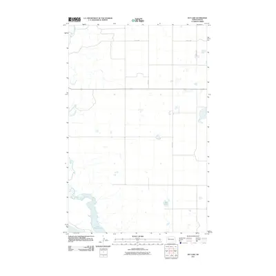
2011 Map of Rat Lake
USGS Topo · Published 2011About this map
Lake Sakakawea dominates the southern reaches of this landscape, its expansive waters meeting the meandering path of the White Earth River as it flows from the northwest. The terrain is defined by the rigid grid of the Public Land Survey System, with gravel and local roads like 57th St NW and 94th Ave NW cutting straight lines across the prairie. The eponymous Rat Lake sits as a smaller, distinct body of water in the southeast, surrounded by numerous small prairie potholes and seasonal wetlands typical of the Missouri Plateau. This 2011 survey captures the area during a period of modern agricultural use and land management, where the intersection of significant water resources and a sparse, organized road network dictates the local geography.
Find a feature on this map
7 named features on this map. Tap any name to fly to it.
Don’t see what you’re looking for? This feature index may not catch every label — zoom into the map to look around manually.
Map Details
Editions of this 2011 Rat Lake Map
This is the sole edition of this map. No revisions or reprints were ever made.
Other maps of this area

1953 · Williston
USGS Topo · 1:250,000

1957 · Williston
USGS Topo · 1:250,000

1965 · Charlson
USGS Topo · 1:24,000

1965 · Charlson NE
USGS Topo · 1:24,000

1979 · Tioga SE
USGS Topo · 1:24,000

1981 · Robinson Lake
USGS Topo · 1:24,000
1981 · Rat Lake SE
USGS Topo · 1:24,000

1981 · Ross
USGS Topo · 1:24,000

1981 · Manitou
USGS Topo · 1:24,000
1981 · Rat Lake
USGS Topo · 1:24,000