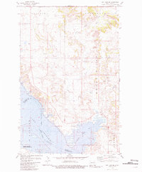
1981 Map of Rat Lake SE
USGS Topo · Published 1981About this map
Lake Sakakawea dominates the southern landscape of this 1980s-era survey, where the rising waters of the Missouri River have filled the jagged inlets of Knife River Bay. The topography here is defined by the transition from the upland plateaus of Brookbank and Osborn down to the reservoir shoreline. Along the western edge, the Antelope Creek State Wildlife Management Area preserves the prairie habitat adjacent to the water. Further inland, the Little Knife River meanders toward the lake, cutting through a terrain marked by local landmarks like Stony Hill and numerous spring-fed coulees. The map also records the boundary line between Mountrail and McKenzie counties, tracking it through the center of the lake. Small-scale industrial activity is evident in the several scattered Gravel Pits found throughout the sections, particularly north of Rat Lake.
Find a feature on this map
13 named features on this map. Tap any name to fly to it.
Don’t see what you’re looking for? This feature index may not catch every label — zoom into the map to look around manually.
Map Details
Editions of this 1981 Rat Lake SE Map
This is the sole edition of this map. No revisions or reprints were ever made.
Other maps of this area

1953 · Williston
USGS Topo · 1:250,000

1953 · Watford City
USGS Topo · 1:250,000

1957 · Williston
USGS Topo · 1:250,000

1957 · Watford City
USGS Topo · 1:250,000

1967 · Watford City
USGS Topo · 1:250,000

1967 · Sanish NW
USGS Topo · 1:24,000

1967 · Sanish
USGS Topo · 1:24,000

1981 · Belden SW
USGS Topo · 1:24,000

1981 · Robinson Lake
USGS Topo · 1:24,000

1981 · New Town
USGS Topo · 1:24,000