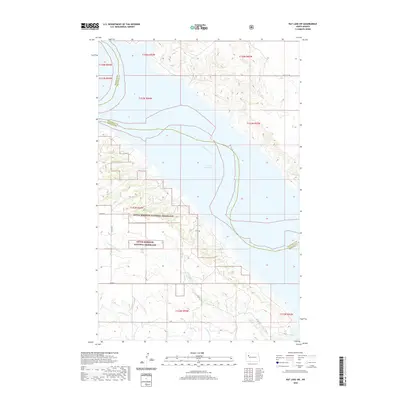
2020 Map of Rat Lake SW
USGS Topo · Published 2020About this map
Little Missouri National Grassland dominates the western and southern reaches of this landscape, where the Missouri Plateau meets the expansive waters of Lake Sakakawea. This modern survey illustrates the complex shoreline of the reservoir, formed by the damming of the Missouri River, which snakes through the center of the quadrangle. The hydrology is defined by the drainage of Little Antelope Cr and Antelope Cr, cutting through the dissected terrain that transitions from open grassland to the water's edge. A sparse network of rural routes, including Co Rte 6 and 48th Ave NW, provides access to the interior of the grassland. The boundary between McKenzie and Mountrail counties follows the old river channel, now submerged beneath the lake, preserving the political geography of the pre-dam era.
Find a feature on this map
18 named features on this map. Tap any name to fly to it.
Don’t see what you’re looking for? This feature index may not catch every label — zoom into the map to look around manually.
Map Details
Editions of this 2020 Rat Lake SW Map
This is the sole edition of this map. No revisions or reprints were ever made.
Other maps of this area

1953 · Williston
USGS Topo · 1:250,000

1953 · Watford City
USGS Topo · 1:250,000

1957 · Williston
USGS Topo · 1:250,000

1957 · Watford City
USGS Topo · 1:250,000

1965 · Charlson
USGS Topo · 1:24,000

1965 · Blue Buttes
USGS Topo · 1:24,000

1965 · Charlson NE
USGS Topo · 1:24,000

1967 · Watford City
USGS Topo · 1:250,000

1967 · Sanish NW
USGS Topo · 1:24,000

1967 · Sanish
USGS Topo · 1:24,000